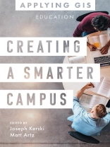
Discover how educators, researchers, IT support, and administrators can transform education inside and out, now and for the future.
Geographic information system (GIS) technology offers a powerful decision-making tool in various aspects of education. It gives educators a new opportunity to teach problem-solving to a tech-savvy generation of learners. Researchers can use GIS for data visualization and integration, and IT professionals can improve the offerings of their cloud-based platforms. GIS offers administrators a way to visualize and manage everything from mapping campus buildings to planning where and when to close schools and open new ones.
Creating a Smarter Campus: GIS for Education explores a collection of real-life stories about education organizations doing just that with GIS. Through their ideas, plans, and goals, they help readers understand how to use GIS and integrate spatial reasoning into teaching, research, and management. A “next steps” section provides ideas, strategies, tools, and actions to help you jump-start using GIS for education. A collection of online resources, including additional stories, videos, new ideas and concepts, and downloadable tools and content, complements this book.
Edited by Joseph Kerski, education manager at Esri, and Matt Artz, an Esri content strategist.
สารบัญ
Introduction
Stories and strategies
How to use this book
Part 1: Educators
Part 2: Researchers
Part 3: IT Support
Part 4: Administrators
Next steps
Contributors
เกี่ยวกับผู้แต่ง
Matt Artz is a principle content strategist for Esri Press. He brings a wide breadth of experience in environmental science, technology, and marketing, and contributed to many books, including COVID-19: GIS for Pandemics, Managing Our World: GIS for Natural Resources, Preserving Our Planet: GIS for Conservation, Mapping Community Health: GIS for Health and Human Services, Keeping People Safe: GIS for Public Safety, and Smarter Government: How to Govern for Results in the Information Age.
